
19.05.2008 09:51
<< 1000 Bugs Killed In 8 Weeks! | The roads I take... | 47 >>
Linuxwochen Wien: Local Community and OSM
This Friday and Saturday, I spent a lot of time at a local free and open source event called "Linuxwochen Wien". Both days I had intended to only visit there for two talks or so, but on both days I didn't come home before 2 in the morning, spending the rest of the evenings and nights with people from the local FLOSS community and talking about all kinds of interesting things.
My first contact with that community (yes, I know, I probably should have done that earlier) was a lot of fun, and I surely intend to repeat the experience. And I even could reply that SeaMonkey 2 and Firefox 3 will improve exactly some of the areas where people complained about Mozilla - though one guy was surprised that we still aren't a GTK application on Linux, because we feel so much like one nowadays that he couldn't tell the difference.
I had lots of interesting conversation with people from CAcert, OpenOffice.org, the FSFE local interest groups, etc. At the official event, I attended a discussion about "Linux vs. FLOSS" (mostly about which name should be part of a mass-targeted event like this), a talk about customizing Firefox (mostly actually listing and demoing "Add-Ons you must have") - and an inspiring talk about the OpenStreetMap ("OSM") project, which works towards free map data, created by a global community.
After 2 days of not getting much "real work" done, I would have thought to dig deep into SeaMonkey stuff today, but instead, I could not get OSM out of my mind. I looked at the currently available maps from my home town of Steyr, which are/were only rudimentary there, and decided to "just improve a few bits" like names of the streets they had in, maybe some missing connections, just for trying how this works. Well, that's what I thought, at least. After I guess about ten hours of naming streets, drawing new areas and streets according to satellite imagery and correcting already existing data, you might be able to grasp the amount of changes I made by a look at the images below - the first is the nicely rendered view of what OSM had before, the second is the current data in the edit view (nice "Mapnik" view will only be rendered mid-week):
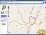
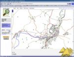
Yes, this really is the same sector of a map, click on the images and view larger version if you don't believe it.
OSM is not just a nice project, I fear I could get hooked on it - not sure if that's a good or bad outlook.
Additionally, I have just added a few items to the list of why I may want to buy a N810, as there's software for it to work with the free map data from OSM and it should also be able to create GPX tracks that I can use with OSM to improve map data. Not sure how long I can hold myself back now before throwing my euros over the counter just to get this device...
Running a Gecko browser on it might even get me back to Mozilla-related work.
My first contact with that community (yes, I know, I probably should have done that earlier) was a lot of fun, and I surely intend to repeat the experience. And I even could reply that SeaMonkey 2 and Firefox 3 will improve exactly some of the areas where people complained about Mozilla - though one guy was surprised that we still aren't a GTK application on Linux, because we feel so much like one nowadays that he couldn't tell the difference.
I had lots of interesting conversation with people from CAcert, OpenOffice.org, the FSFE local interest groups, etc. At the official event, I attended a discussion about "Linux vs. FLOSS" (mostly about which name should be part of a mass-targeted event like this), a talk about customizing Firefox (mostly actually listing and demoing "Add-Ons you must have") - and an inspiring talk about the OpenStreetMap ("OSM") project, which works towards free map data, created by a global community.
After 2 days of not getting much "real work" done, I would have thought to dig deep into SeaMonkey stuff today, but instead, I could not get OSM out of my mind. I looked at the currently available maps from my home town of Steyr, which are/were only rudimentary there, and decided to "just improve a few bits" like names of the streets they had in, maybe some missing connections, just for trying how this works. Well, that's what I thought, at least. After I guess about ten hours of naming streets, drawing new areas and streets according to satellite imagery and correcting already existing data, you might be able to grasp the amount of changes I made by a look at the images below - the first is the nicely rendered view of what OSM had before, the second is the current data in the edit view (nice "Mapnik" view will only be rendered mid-week):
Yes, this really is the same sector of a map, click on the images and view larger version if you don't believe it.
OSM is not just a nice project, I fear I could get hooked on it - not sure if that's a good or bad outlook.
Additionally, I have just added a few items to the list of why I may want to buy a N810, as there's software for it to work with the free map data from OSM and it should also be able to create GPX tracks that I can use with OSM to improve map data. Not sure how long I can hold myself back now before throwing my euros over the counter just to get this device...
Running a Gecko browser on it might even get me back to Mozilla-related work.
Beitrag geschrieben von KaiRo und gepostet am 19. Mai 2008 05:02 | Tags: Firefox, Linuxwochen, Mozilla, OSM, SeaMonkey | 3 Kommentare
TrackBack/Pingback
Kommentare
| Autor | Beitrag |
|---|---|
JanV aus Netherlands |  Make sure to check http://wiki.openmoko.org/wiki/Main_Page before buying your N810. |
Ted Mielczarek | Pretty easy to get hooked on OSM. I mapped my whole hometown:http://openstreetmap.org/?lat=40.68747&lon=-75.48639&zoom=15&layers=B0FT 20.05.2008 03:45 |
BlueMM aus Melbourne,Australia | I saw your user page appear on the OSM wiki, and wondered if it was the same KaiRO. It can be addictive when tracing Yahoo! imagery in Potlatch, but like most things, it comes in bursts (especially after you had finished around your home town). I too don't have a GPS, so am mainly tracing at the moment. I have gone out and surveyed street/park names, facilities etc. but it takes a long time. I've surveyed maybe 2% of what I have traced!! I'd recommend turning off the faded layer for Y! imagery when tracing, and turn off the special pointers. 20.05.2008 04:36 |