<< Weekly Status Report, W37/2012 | The roads I take... | Integration eines Magento-2-Webshops mit FreeFinance und selbstgebautem Warenmanagement >>

Lantea Maps - Contributions Welcome!

Image No. 23111 Image No. 23112 Image No. 23113

I just split my Lantea Maps web app out of my main git repo and into its own small one, one main reason being that I can place it on GitHub as well. This is not meaning that I suddenly love the GitHub site, but having the repo there lowers the entry barrier for potential contributors and I'd be very happy to have people help me with this app.

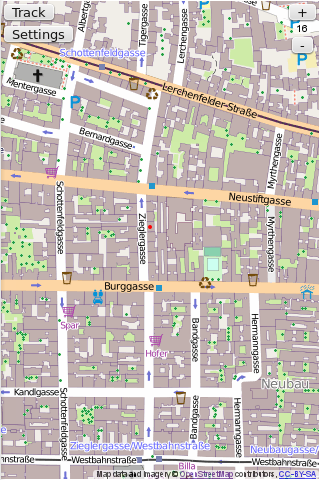
Lantea Maps is a prototype web app to display maps and record (GPS) tracks, and I found it works pretty well with Firefox OS, actually. It's one of the apps I keep installing on my test device for that system, of course from its Mozilla Marketplace listing.

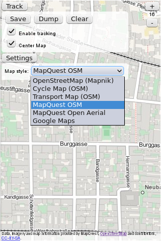
The app is based on a canvas that displays a map (from OpenStreetMap, multiple styles can be selected) and on which the recorded GPS tracks are displayed. The start of the app is there and working, but it could need quite some improvement - like making zoom switches and probably map panning smoother by using some canvas magic, supporting pinch gestures, caching tiles not just during a session but also across sessions (using IndexedDB), and more.

As mentioned on the original Lantea idea wiki page, there's a quite nice app for the Nokia N900 called Mappero that is a good source for feature and UI ideas, for me it's one the the best apps in that space and I'd love to have something similar to it as a web app - which is basically why I started Lantea at all.

That said, I'm open for all kinds of ideas for it - and even more, to patches and pull requests! :)

Beitrag geschrieben von KaiRo und gepostet am 21. September 2012 01:17 | Tags: B2G, Lantea, Mozilla, OSM, Web Apps | 3 Kommentare | TrackBack

Kommentare

AutorBeitrag

Archaeopteryx

zitieren
Hallo KaiRo,

das sieht doch gut aus. Zwei Dinge:

1) Die OSM-Daten stehen jetzt unter Odbl-Lizenz, ich habe nicht überprüft, ob sie von vor dem Lizenzwechsel sind.

2) Wie oft wird eine Position mittels GPS aufgenommen?
21.09.2012 09:50

KaiRo

Webmaster

zitieren
Archaeopteryx:

1) Ja, das mit der Lizenz weiß ich, muss mich erst umsehen, wie ich die Copyright-Mitteilung am besten daran anpasse, ohne dass sie zu lang wird, denn die Daten sind ODbL, aber die Tiles nach wie vor CC-BY-SA.

2) Es wird Geolocation.watchPosition() verwendet, und das ist dem Browser überlassen, wie oft ein Callback gesendet wird. Laut DougT sendet der Mozilla-Code das "wenn sich die Position signifikant ändert", so weit ich sehe, ist das maximal jede Sekunde.
21.09.2012 14:30

Harry

aus London UK

zitieren
Feedback
I'm an open street map editor with a firefoxOS phone, so Lantea was an obvious choice.

I find it works well. I had the original ZTE open which just about worked, but now upgraded to an Open C which is a lot better -- more memory and CPU power, but especially the GPS seems much more accurate. Downside -- they've dropped the compass, which was useful, so now I know more exactly where I am, but cannot tell which was I should go until I have been moving for a while.

Minor issue with Lantea -- the configuration buttons pop up every time you touch the screen, hide rather a lot of the map and take a while to disappear. I would prefer to have a small config icon brings up the buttons.

Possible features -- when in centre mode, I'd like to be able to drag the map to see more in the direction I am going, but at the moment it immediately puts me back to centre unless I manually disable the centre mode. It would be good if dragging could temporarily disable the centre mode and have an icon to click when I want to go back to centre.

Its good to see the OSM map notes -- I wonder if you could do the same with GPX points retrieved from either local files or static URLs which the user could configure and display in the same way. They could be preplanned route markers, conventional POI lists, OSM keepright errors or anything the user chooses.

Conversely, it would be good to be able to save some geo-notes relating to a position. Identify a position (perhaps the current GPS location, but possibly instead that of a nearby landmark) and make a text note or maybe a photo).
23.07.2014 15:54

Kommentar hinzufügen